Friday, June 22, 2012

Rakkup Guide Book App

Here's an app that uses GPS locationing to get you to your climb. Not sure how it works with elevations... Works offline. http://www.rakkup.com/

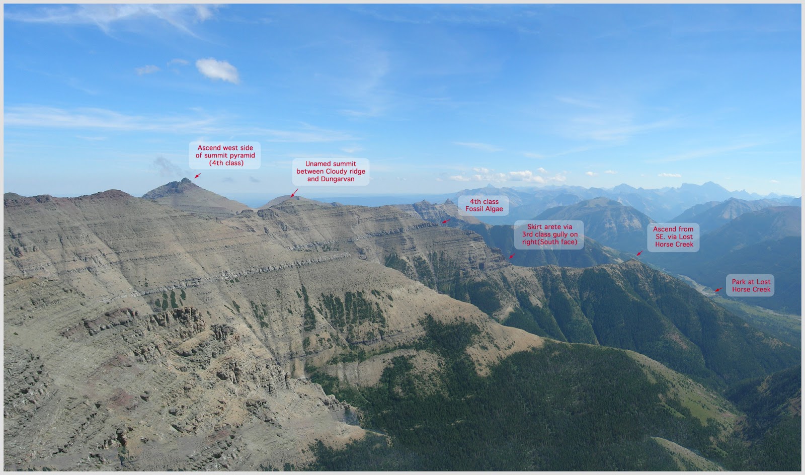
The next step up, which I had thought about was a virtual reality overlay. This is similar to the peak finder app. The idea here would be to overlay route arrows onto your camera's real image. Therefore you would point your camera at the cliff you are at and it would highlight the routes and spit out some extra info.

The data crunching is too tough for this. Tree foliage at different times of years confounds the vectors you need to store in order for an object to be recognized. This type of augmented reality uses GPS locationing to filter the database of all possible locations. It then uses "edges" to match what you see to what has been loaded into your virtual reality server. It then spits out the augmented reality layer onto your camera's image. Layar is one of the basic tools for this.

Monday, June 18, 2012

App Store Submission

SA Rock
I've finally been able to hit the "submit" button for the Southern Alberta Climbing Guidebook.  Barring any unforeseen rendering glitches it should take 5-10 business days to process.  That means an arrival date right around Canada day.

I haven't finalized the price, but I'm thinking 4.99.  That means about 3.50 per app: requiring about 100 downloads to break even for this year's publishing costs, and about 60 per year thereafter. Around here I think 100 downloads is a bit overly optimistic, but guidebooks really are more of a community service project than anything else.

4th Edition
I plan on updating the app in late August, and will try to do a yearly update thereafter.  After 1 year, I'll take a look and see if I want to get rid of the update feature and do a one-time submission for $250 (or spend lots of time figuring Adobe's phone gap publisher and a deeper level of how apple's submission / development processes work.  Doubtful.)

I'll probably try for the Android Store here in a week or two.  I'll need some time to recuperate from all the paper work required to get it through the app store.


Feeback on the price.....?  Most of the other guides are selling at around print retail - $8 to $30.  More for the big areas (2000 routes) less for the smaller local areas (300 routes).  I just can't see that making sense for a self-published guide to a bunch of crappy cliffs.


Sunday, June 17, 2012

Summer Folk Fests

Outside of the regular folk fest, here are a couple of options that would go great with a climbing trip

Butte - Nice granite climbing just east of town on the King
http://montanafolkfestival.com/

Libby - Stonehill climbing
http://www.riverfrontbluesfestival.com/

Helena - lots of great climbing all over
http://goldwest.visitmt.com/listings/13376.htm

Fernie - maybe the locals will fess up about some of their developments.  If not, lodgpole road has lots of new route potential.
http://wapitimusicfestival.com/

The Butte festival is by far the best.  The Libby one has a nice relaxed vibe.

Thursday, June 14, 2012

Dungarvan South West Ridge Scrambling

I'm trying to play with some alternative ways of labeling scrambling route images. The following image seems to work well on a computer, but seems to struggle on an iPod. I've tried rotating the image to allow the magnification limits to work better.  Still seems like the text needs to be a big bigger.  Too much more though and I worry about it being too cartoony...


The updated app image - thanks Mark


Monday, June 04, 2012

Contact Info For Climbing HIstory

Just looking for some contact information for any contact information people may have for old route pioneers...

Chris Morris, if you read this, I can't find a way to get hold of you to check out your routes in the pass.  Any chance of sending me your email or phone?

Chris - cgoble72  at gmail

Sunday, June 03, 2012

Porcupine Lookout

I'm a bit embarrassed to say I've never been up Porcupine Lookout (or Goat Haunt Peak).  I always thought Porcupine lookout was decades overgrown.  Guess I was wrong....


Friday, June 01, 2012

Southern Alberta Guide Book Climbing App

Well, after a bit of help verifying content and linkages, I'm in the final wind down for the app.  Hopefully I can get it finished this weekend, nearly meeting my June 1 deadline.

Here's what I have left to get things "good enough" to publish to the app store.

  • Write up Yarrow E ridge alpine rock route from Blair's notes
  • Write up Crowsnest Mtn Scramble from my notes, verifying and referencing with other online descriptions. - Not enough time..  I'll leave this for summer and open the door for all the "Waterton-centric" complaints.  Just not enough time to do all the verifications needed...
  • Compile research on Citadel Spires and phone Paul to grab any of his pictures and get a rough grading
  • Compile the research I have on Cleveland's North Face to write up a basic description.
  • Create an alpine ? grade icon
  • Create Thunder Mountain icon
  • add images to yarrow page
  • add images to anderson
  • Add images and photoshop in routes for 7 alpine rock routes & 6 scrambles.  - images left to do.
    • Alderson - will have to wait until summer update
    • Dungarvan
    • Crandell

  • Add a list of FA by author 
  • Add a list of FA by decade - done, but needs app formatting (1hr)
  • Increase the vertical spacing on notes & updates icon for the Notes page
  • Update info for two Bear's Hump projects
  • Update the Bear's Hump Route Image Legend with the new names

  • Create mini-thumbnails for most of the alpine rock & scramble routes  - Mostly done (Crowsnest upload, Cleveland get & upload left)
  • Decide if I really want to explore adding a recessed table look for route rating sections. - no go because I have to change the CSS which the company doesn't easily let you change.  Plus the grey color scheme makes it challenging to design without adding way to many focal points on a single page.  Therefore, no slick look like Mountain Project's recessed round corner windows.
  • Verify if I ever updated the route marking colours for the Reservation Slab.
  • Verify that all crag descriptions have "Getting There" as the first section..... Janson :) ? - Screw that.  While "Getting there would be nice to have at first, is there really a point to Intro info coming at the end of the page.  I think I'm going to switch things back to a normal guidebook layout rather than a "what info will a user refer to most frequently" approach.  I've changed my mind again.  I'll spend the couple of hours to move "Getting There" to the top.  I'll also have to change all the "Introduction" headings to "Overview" headings.
  • Add GPS coordinates for most crags.
    • Gap
    • Crowsnest Pass
    • Drywood
    • Waterton
    • Scrambles - will have to wait until summer update.  
    • Alpine
    • Prairies - I've decided to cut out the bouldering info.  Too much of a distraction

  • Add a red header for "About" page.
  • Write an info page on Alpine Rock Routes
  • See where the heck my Wishbone climbing pictures are (I have some half digitized ones from last month :(
  • Add info for undeveloped areas (copy from old word doc) - I suspect I'll skip this due to time.  I'll throw it in my Aug. update.
  • Create a menu page & info for nearby climbing areas.  - Just doing a link to various guidebooks.  I'll see if I get time tonight to dig up the old notes on unexplored areas.  I'm going to skip the summary of various weekend destinations.  Its just not worth the return for my time.
  • Add a page of links or images for relevant guidebooks.
  • Icon for Cleveland NF.
  • Split Citadel Spire into two routes.
  • Barnaby & Carbondale crag icons & images.


  • Decide if I want to keep "Prairies" area and just include Glenwood Boulder and the couple bits of route info I have, or change it to Bouldering and also include two or three sentences on Frank, the boulder up at Expert's choice, & the boulders behind the warden's compound. - getting rid of bouldering for this edition
  • Buy apple developer license $100-$150 - ordered June 16.  Should be here by June 17.
  • Buy app publishing fee $100 + $10/month - 1-2 days for iPhone and 5-10 for apple.  App should be ready on the apple and android markets June 27 to July 2.
  • Decide if I have the time to do a better logo than the ugly green one I have.  Probably not... - updated.  Would have been nice to do a border and add a bit of a red effect on the hiker.  No time (the ugly green is the old icon.  It didn't match the app colour scheme)
  • Copy old info to a single page for "Undeveloped Areas"
For Summer Update
  • old picture of frank goble
  • interview videos/podcasts
  • better Blakiston photos
  • Gargoyle ridge (better route diagram)
  • Medicine Hat Wall (thunder mountain) routes
  • Knob Hill, Another Day Care area & roadside info
  • Emerald Lake route photos & details.
  • add old guidebook front pages in "about page"
  • update FA grade to show Crag, not year as 4rd column.
  • Add more scrambles
  • Remove pictures from Scrambles and Alpine and put them into a photo album for each route

Hmm.... maybe that is a lot to do.

I do like having the Alpine rock section in there.  That and the scrambling really make this a robust guide.  Of course it opens up a slew of never ending additions....

Email me